
Urban Digital Twins
A New Technology That Could Save Coastal Cities
Written by Lili Biglari
When a flood hits a community, devastation can overwhelm residents, but being proactive and preparing for such disasters can make a big difference. Urban planners are increasingly looking to utilize technology to highlight the areas that are most at risk of floods. New research explores how the use of urban digital technology (UDT), which integrates data and the physical environment, is used with a dashboard. The paper helps find out if these two technologies work well together to educate the public and to create climate resilience measures.
In Cedar Key, FL, planners have set up this dashboard to engage and inform residents. The website includes data on risk reduction, natural landmarks, flood scenarios, hurricanes, and more. The Resilient Cedar Key project is successful because it uses these two technologies - UDT and geospatial dashboard - to inform the potential climate change impacts and anticipate that resilience planning. However, there are setbacks because the site and UDTs in general are not always user-friendly.
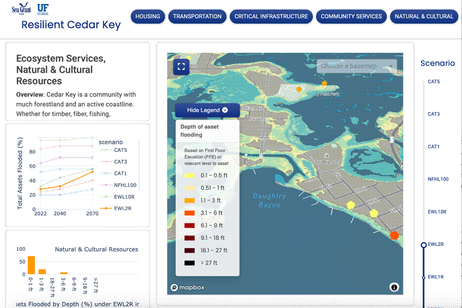
The screenshot above shows how there is a lot of information on the site, but it can be difficult to understand at first glance. If we want the use of these kinds of dashboards to be a great educational tool for communities, it must show a more simple way for people to understand this visualization of potential flooding impacts. Specifically, if it is visualized in a way that the general public can understand, it would improve community competency and would build skills to think about the risks of floods in their area. It will be exciting to see if the use of these kinds of dashboards will continue to grow and be used with other technologies, like the Cedar Key, FL case study showed.
If you are interested in reading more about this study, check out Integrating Urban Digital Twin with Cloud-Based Geospatial Dashboard for Coastal Resilience Planning: A Case Study in Florida (2025) which can be found in the Journal of Planning Education and Research (JPER).
Citation: Chen, Changjie, Yu Han, Andrea Galinski, Christian Calle, Jeffrey Carney, Xinyue Ye, and Cees van Westen. 2025. “Integrating Urban Digital Twin with Cloud-Based Geospatial Dashboard for Coastal Resilience Planning: A Case Study in Florida.” Journal of Planning Education and Research, February. https://doi.org/10.1177/0739456x251316185.